October 28, 2011
Friday we awoke at 5:30 am to grab breakfast and pack up to leave. The morning’s agenda was a trip into Colca Canyon, the deepest canyon in the world and the perfect place to see condors. We began on a dirt road into the canyon. The first part wasn’t incredibly deep, but man was it beautiful. There was a tunnel that was so full of dust I could not see 5 feet in front of me, I had to look at the side of the road on the ground next to me to know where I was going. That was interesting.
 Pre-canyon photos


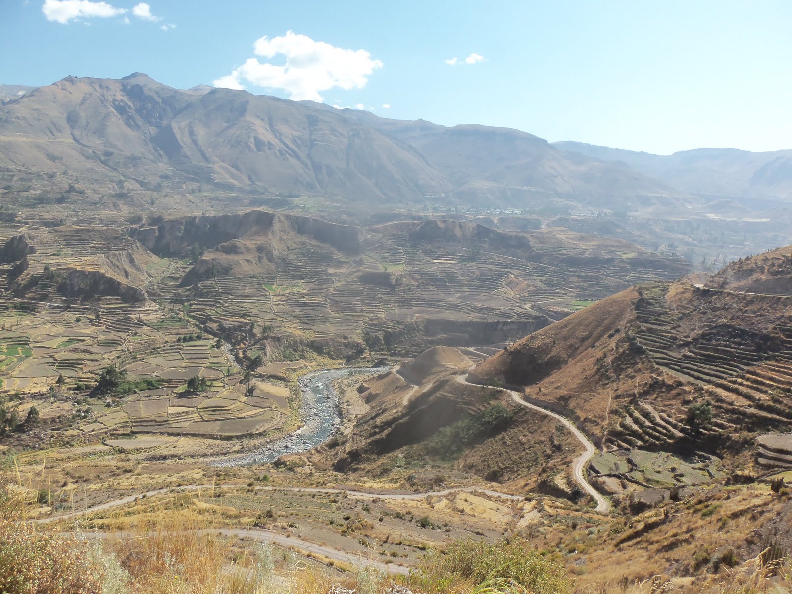
 A panoramic from one of the many tourist stops
 The tunnel was a lot darker, the flash helped this photo...


After driving for about an hour or so, I came to the station where people have to pay to continue. I asked if there were any discounts from the 35 S price. The man smiled and said no. I continued to explain why I was in Peru and just chatted with him for a bit. I went to the window and the woman told me she was charging me half-price, that’s what Peruvians pay. Heck yes.
I went a little longer, stopping for the occasional picture when all of a sudden I looked to my right. I lost my breath for a moment. What an unbelievable sight, I was looking two miles straight down!
I parked at the viewing area which was packed with people. I heard someone shout my name, it was Juan! His house is where I park my motorcycle in Ollanta! Here I was a three day ride from home and I ran into him. I then found the group and the five of us just sat on a wall and stared. It was so hard to get pictures showing what we were actually looking at. Then, off in the distance we saw two condors. Even from such a great distance they were magnificent. Slowly, they turned and headed straight for us. One passed about 20 feet below us. What an incredible creature.
 Allegedly it is 2.5 miles from the top to the bottom of this picture
 Yup, pretty amazing
 The first condor flew right below us
The second not as close, but I thought a video would be cool

 Goodbye Colca Canyon
As they left in the tourist bus, I ran into a man from France on a KLR 650 he bought in Ecuador. We chatted in Spanish for a bit, then I caught up with the tourist van. I was confused because once again google maps showed there was a major road going west through the mountains, but the van was headed back east to the main highway. I talked to the bus driver and he said I could go west, but it would take about 6 hours. So my choices were go back the way I came on a nice highway, or take a dirt road through the mountains creating the deepest canyon in the world. I was a little nervous about time, since it was now 11:00 am. But whatever, I came here to experience life on a motorcycle and wasn’t going to pass this up. I said goodbye to the group and set off.
And what a choice it was.
It began easily enough on a paved road. That lasted 10 minutes. I turned off on a tiny one-lane dirt road, which was pretty rough at times. I passed a SUV about 5 minutes in. It would turn out to be the last vehicle I would see for 6 hours.
The views continued to be stunning. After about an hour and a half I stopped for lunch. It was so quiet and peaceful there, up on the mountain so far away from everything. All I could hear was the wind blowing through the rocks. Once again the thought occurred to me, how did a math teacher from Michigan end up on the top of a mountain in Peru on a motorcycle.
 An hour after Colca Canyon
 Tough road
 10 second timer... what a weird place to find a math teacher
 View during lunch
 Obligatory Beach Challenge photo. Missed it again this year, miss you guys
 Dropping into Huambo
The ride was constant climbing and descending, and endless hairpins turns. Being a dirt road, I rarely made it above 20 miles an hour. But it was enjoyable and I was constantly stopping for pictures. About 2 hours in, I passed the tiny town of Huambo. I saw a man on a horse and not much else. He would turn out to be the last human being I would see for 3 hours.
Past Huambo is where the ride really began. About every 20 minutes I would enter another valley. I think in the entire day I went through 16 valleys. I would climb up the sharp turns, then all of a sudden I would turn a corner and shoot out into a new valley. Several times my stomach jumped as I was greeted with the vast Earth laid out before me.
But it never stopped. Time kept passing and I realized I had not seen any evidence of human existence besides the road. There were no structures of any kind, no pastures, no fields, nothing. I had not passed another vehicle in hours.
The beautiful desolation was complete.
And then the mental games began. What if I went down in the rocky, sandy road? What if the bike broke down? How many days would I be out there? My hands were getting tired from the constant braking and changing of gears, muscling my way through the endless mountains.
Endless.
I think if I had had someone there with me it would have been fine. But home had never seemed so far away before, and when I say home, I mean Ollantaytambo. Grand Haven felt like another world, or a past life. It was a place from a dream, from a storybook but not concrete enough to seem real.
I stopped to take a panoramic of yet another valley when my camera died. I was going to call the photo, “Welcome to Desolateville, population me.” Finally in the distance I could see a huge arch over a turn in the road. My gps was sending me that way! Yes! The arch read, “Welcome to Lluta”. I thought I finally was going to reenter civilization. The gps said 14 miles, that isn’t too bad, right? Oh no. The road markedly worsened. It took an hour to get there. With the dead camera, I missed a couple dozen more amazing photos. That makes me sad, but I don’t think I will soon forget that stretch.
 Bridge after Huambo
 Valley with the lonely road cutting through
 This is how I felt all day
 Another valley
 Cool dried lake I got to drive through
 Another valley
 Another valley
 Another valley, hmmm, is there a pattern here?
I finally reached the city. I stopped in the plaza and asked a boy walking by, how long to get to Arequipa? He told me four hours. Four hours!! What? It was already 4:00 pm. I was whipped. I couldn’t take another four hours of hairpins and dirt. But I had to press on. I stayed there for about 2 minutes and just got right back on the road.
After awhile I broke out into yet another valley. But this one was much steeper and narrower than the ones I had been going through. I saw the other side and it was the tightest climb yet. I laughed. No way, straight down and straight back up. I remembered I had my iphone in my bag, so I got it out and started photographing again. It was 1,500 feet down and right back up on the other side.
The next town was Cincha. I blew through it trying to beat the sun to Arequipa. The valleys did not stop, but definitely stayed amazing. I took what I thought was my last photo and cursed loudly in my helmet. I wasn’t going to stop anymore to document this stupid, beautiful landscape. Then, of course, Peru shot back with an amazing view of a solitary mountain watching over the never-ending valleys.
Then, finally, out of nowhere, a brand new, two-lane, completely paved and marked highway simply appeared. There were still no structures or civilization, but I wanted to get off the bike and kiss that road. I have seen pictures of adventure motorcyclists doing that, and I always thought that was stupid. I prefer dirt roads. Haha, not after this day. But it lasted for about 20 minutes, and as quickly as it appeared, it stopped. I was back on the dirt. So Peru built a perfect highway in the middle of nowhere, from nowhere to nowhere. It makes perfect sense if you don’t think about it.
 Just before Lluta, somehow I squeezed one more picture out of my dead camera
 First Iphone photo. This is the ridiculous down and up.
 At the bottom
 Driving up the other side
 Past Chinca
 Right after I cursed that I wasn't going to stop anymore
 Another valley
 The amazing highway to nowhere
 Back to dirt, but there are still amazing views
I finally reached the outskirts of Arequipa, and as if to drive the point home of the most beautiful ride ever, the sun was setting perfectly on one of the mountain ranges. It was halfway exposed, and the outline of all the mountains I had covered that day branched out along the horizon. What a view to end with!
My ordeal was not over, however. On the busy two-lane road into town a truck passed right in front of me, right in my lane and I had to veer onto the shoulder to avoid it. The guy even flashed his brights as if to say it was my fault for driving in my own lane. The traffic downtown was at a standstill because several roads near the plaza were closed due to some festival. I didn’t get to the hotel until after 7:00 pm. But it was so nice to be greeted by everyone at the hotel. Jake even came into town to find me and take me to the hotel. He then bought me a delicious, expensive dinner. Thank you. Very much.
 Sunset
 A different angle
I don’t know what to think. Would I make the same choice if I had it to do over? Yes. Would I do it again? Not so much. Don't get me wrong, it was an amazing ride. I am really glad I did it. I think the unknown just threw me off a little bit. I guess if I had started earlier, had known what lay ahead, had my tent and sleeping bag, and had a riding partner, I would do it again in a second. But that was rough. I needed it though, I need to be mentally tough in addition to everything else I have in order to make it home. Every good and bad adjective I can think of would apply to that ride. Amazing, treacherous, heart-stopping, desolate, exciting, stressful, tranquil, lonely… what a day.


